
Is December off to a frosty start? This question could be asked when looking at the 00z model run of the so-called HRES model of the ECMWF on 20.11.2022 today. This showed a high-pressure area from Russia to Scandinavia, which would result in cold air reaching Central Europe with an easterly flow.
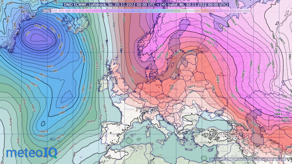
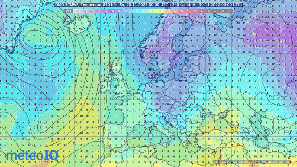
Thus, according to the HRES forecast, the temperature at 850 hPa (approx. 1,500m) in Germany would be around -10°C. The temperature at 850 hPa is used as an indication of the prevailing air mass, since at this altitude the influence of the ground is much less than at 2m.
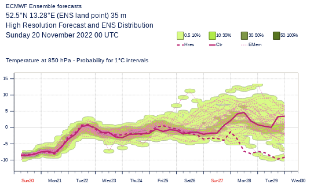
Just one of many – fifty different predictions are better than a single good one
The ECMWF weather forecast model is one of the best in the world. Nevertheless, this one high-resolution forecast is not sufficient to forecast the weather development in the next ten days in the best possible way. Rather, ensemble forecasts are required for these so-called medium-term forecasts.
At the ECMWF, the forecast model is started fifty times with slightly different initial conditions. This reflects the fact that the exact state of the atmosphere is also unknown in reality. Small changes at the beginning can lead to different results in the course of the forecast time.
And so the diagram with the results of the 50 calculations for a grid point in eastern Germany show that the HRES forecast (dashed) is only an outlier for the end of November compared to the 50 other ensemble forecasts, at least currently.
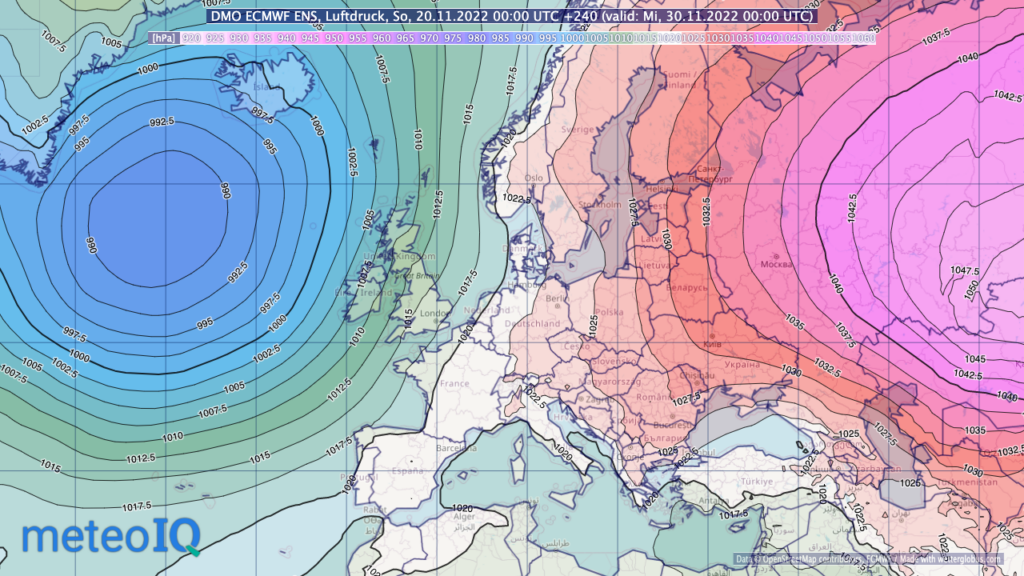
Ensemble average shows coarser but more realistic picture
A better impression of the weather development in 10 days is therefore obtained by averaging the 50 forecasts. Although this means that details are lost in the forecast, the possible position of the high and low pressure areas and general flow conditions are much more relevant over this forecast period.
The ensemble mean for the air pressure forecast on Nov 30th 2022 thus also shows a somewhat different picture than the HRES forecast shown above. Although very high air pressure is also present over Russia, there is no high-pressure bridge to Scandinavia. Low air pressure can be detected over the North Atlantic. This means that Central Europe is more likely to be in a southerly flow in the transition area between mild air in the west and cooler air in the east.
And what will it be like at the end of November in Central Europe? Of course, we don’t know exactly. If we only had the HRES run available, we would assume a frosty weather situation. With the ensemble forecasts we know that this is an unlikely scenario and milder variants are more likely.
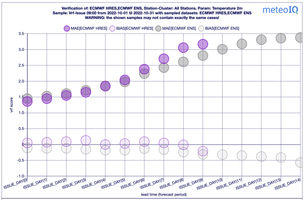
Better forecasts from the 5th forecast day onwards
But at what forecast day is it better to use an ensemble forecast, even if the main run has a higher resolution? The following graph shows the mean error (MAE) of the 2m temperature forecast for a global station selection. Smaller values show better forecast performance. It is easy to see that the ensemble forecast in grey is already equal to the main run in pink on the fifth day. As the forecast time increases, the error of the ensemble forecast is then significantly smaller than that of the HRES run.
MeteoIQ routinely verifies various numerical weather prediction models and statistically optimised point forecasts. The results are published on our website https://verify.meteoiq.com. This information is helping users to determine which provider makes the best forecast for them. Forecast operators gain important insights into where their methods are particularly strong and where improvements can be made.