
There was already very heavy rainfall in northern Italy in April and persistent rainfall was also concentrated in this region at the end of the first week of May.
Rainfall in April 2025
At the beginning of the second half of April, areas of low pressure moved along the French Mediterranean coast towards northern Italy. These were associated with low-pressure troughs extending far to the south, which swung across Europe from west to east. This resulted in an extremely rainy period, particularly in northern Italy.
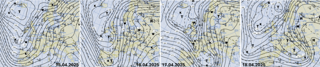
Flow pattern at 500 hPa level, 00 UTC, ahead of low-pressure troughs, warm, humid air was transported from the Mediterranean towards the Alps with a brief interruption from 15 to 22.04.2025 (source: Berliner Wetterkarte)
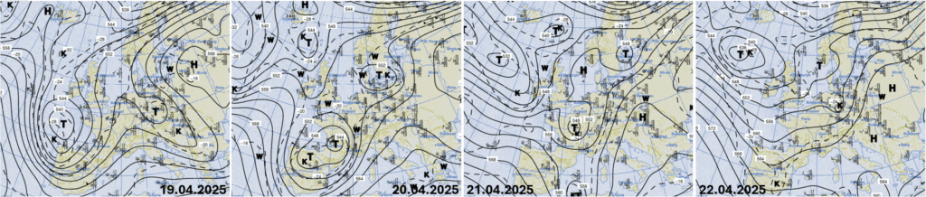
The precipitation peaked on April 16 and 17 and on April 19 and 20, when the warm air was forced to slide into much colder air under the influence of low pressure.
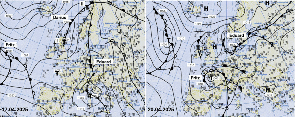
Air pressure distribution at ground level, 17. and 20.04.2025, 00 UTC (source: Berliner Wetterkarte)
The amounts of rain were considerable. In the north-east of Italy it was widely more than 400 l/m2 in one week, in Piedmont partly in 72 hours alone, locally more than 600 l/m2 were measured in 7 days. For comparison, the normal annual precipitation in Berlin-Dahlem amounts to 582.4 l/m2.
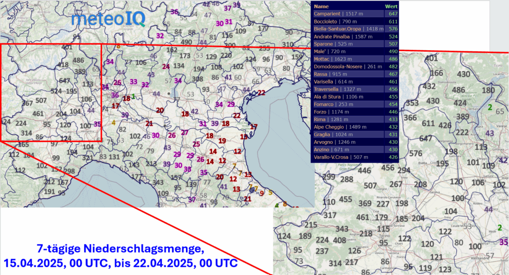
Precipitation amounts of more than 400 l/m2 in 7 days (source: MeteoIQ)
The distribution of the amounts over time is illustrated by the hourly precipitation amounts at the Camparient station (1517 m, in the Alpe di Mera – Scopello ski area). At altitudes above 2000 m, there was a significant increase in snow, in some cases by more than one meter, which increased the risk of avalanches.
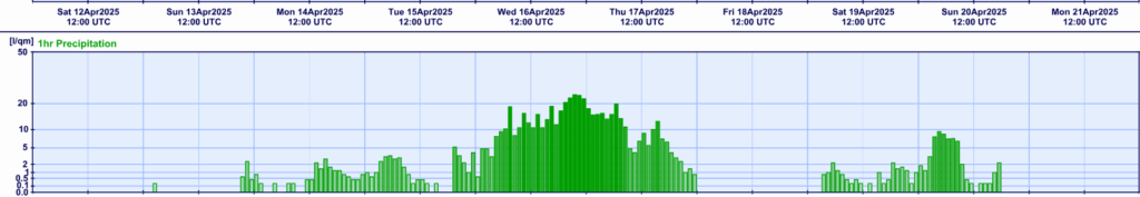
Hourly precipitation at the Camparient station (source: MeteoIQ)
Many rivers in Piedmont flooded, resulting in water exceeding the river bed and landslides. On the Po, into which the rivers from the Italian Alps flow, the water level rose rapidly. At the San Sebastiano da Po gauge, downstream of Turin, the water level reached the first alarm level of 3.3 m on the evening of April 16. The second alarm level at 4.4 m was crossed in the late evening and the third at 5.9 m early in the morning of April 17. The peak water level reached a maximum of 6.95 m in the afternoon. In contrast, at the beginning of the second week of April, the value was barely 1.5 m.
The rising water level after 20 April 2025 was almost harmless in comparison.
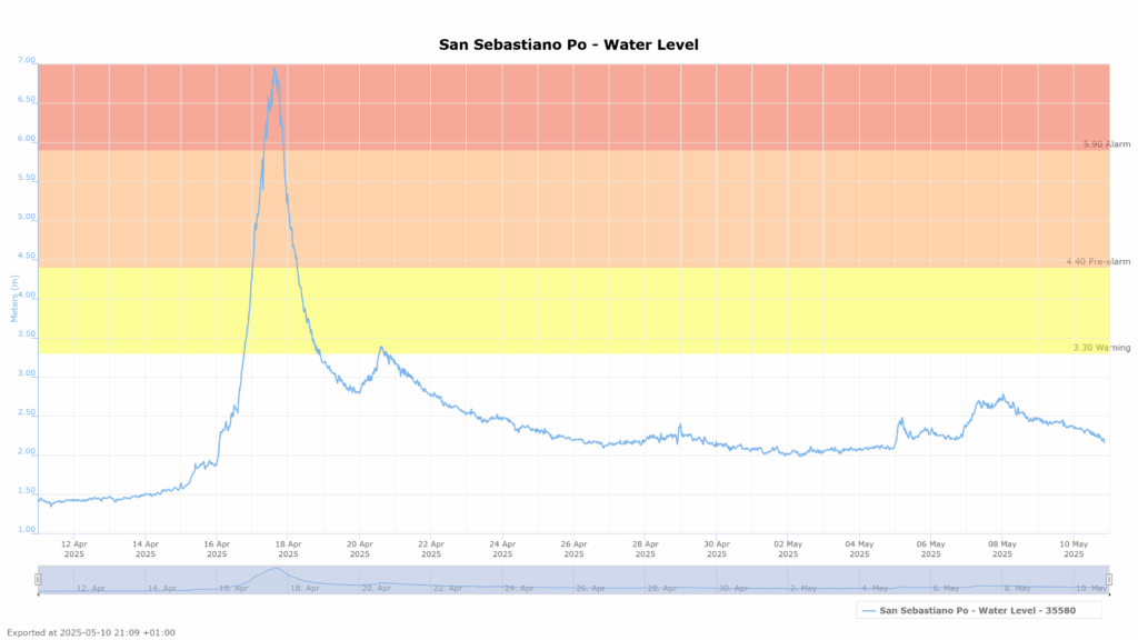
Water level at the San Sebastiano da Po gauge from 12.04.2025 to 10.05.2025 (source: AIPo)
Rainfall in May 2025
A similar constellation of air pressure conditions upper air and on the ground as in mid-April occurred at the end of the first week of May. Once again, so much precipitation fell that streams and rivers in northern Italy swelled. However, the impact was lower in the north-west of the country compared to three weeks earlier, as the water level at the San Sebastiano da Po gauge also shows.
Once again, however, it was a high-altitude trough extending from northern Europe far to the south, or rather a high-altitude low cutting-off over France. At ground level, the low-pressure system ‘Jürgen’ turned over the Gulf of Genoa and brought heavy rain to the Alps.
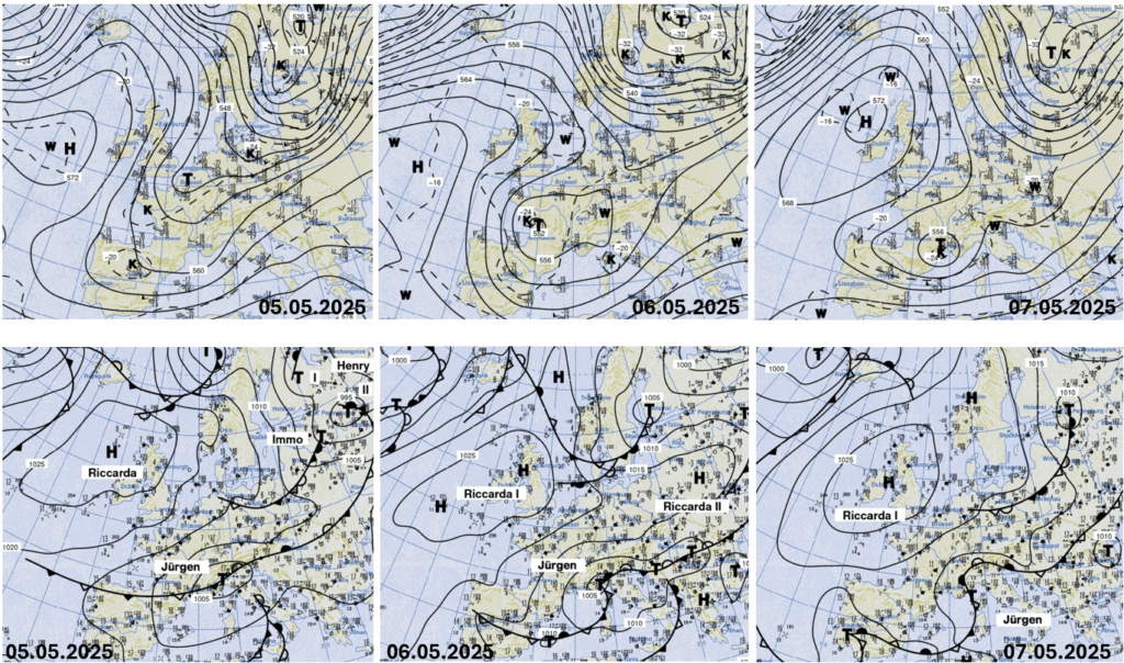
Air pressure distribution at 500 hPa and ground level, 05 to 07 May 2025, 00 UTC in each case (source: Berliner Wetterkarte)
This time, the rainfall was centred not only in the north-west of Italy with just over 100 l/m2 in 72 hours, but also in Liguria and especially in the north-east in Friuli-Venezia Giulia. The Chievolis station recorded 228 l/m2.
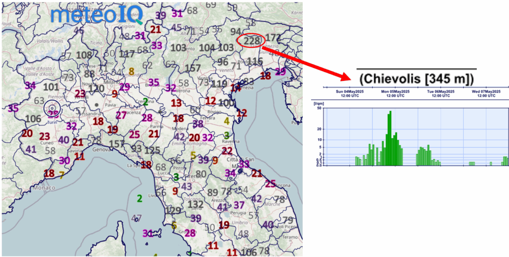
72-hour precipitation amount and hourly precipitation amounts at the Chievolis station (source: MeteoIQ)
On the River Livenza, the Meduna gauge showed a maximum water level of just under 3 m on 6 May 2025, slightly higher than during the precipitation event in mid-April.
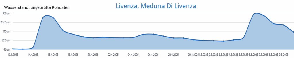
Water level at the Meduna Di Livenza gauge from 12.04.2025 to 10.05.2025 (source: pegelalarm.at)
After the weather calms down briefly, the forecasts show another low pressure system over the north of Italy as early as midday on 12 May 2025. Rain, intensified by showers and interspersed with thunderstorms, is expected again. On the other hand, the dry high-pressure weather will continue in over large portions of Central Europe.
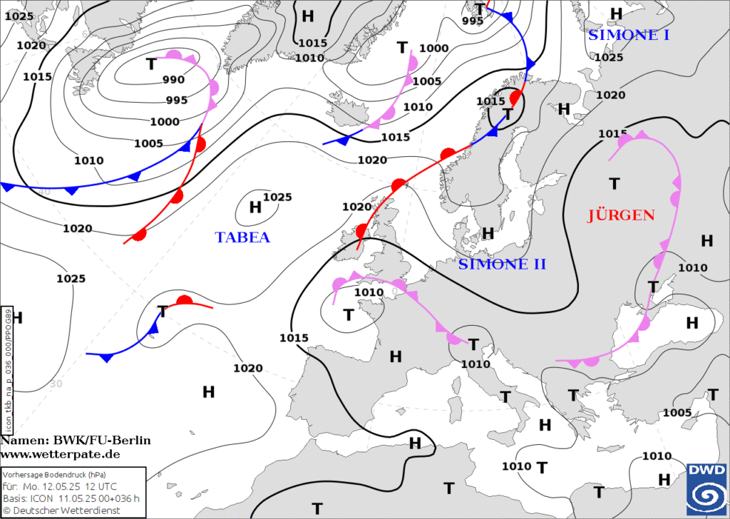
Forecast, ground pressure, ICON model of the German Weather Service from 11/05/2025, 00 UTC, for 12/05/2025, 12 UTC (source: Aktion Wetterpate)
Support in the event of weather-related damage
You can find information on our insurance services at https://www.meteoiq.com/#insurance. We would be delighted if we could support you too.